Advanced Uni-sensor Rapid Orbit Reconstruction Algorithm and Sensing (AURORAS)
As congestion in space grows, there is an immediate need to increase the speed and accuracy of orbit ephemeris determinations for new or maneuvered objects in space. To meet this need, ARA carried out an IR&D effort called AURORAS - Advanced Uni-sensor Rapid Orbit Reconstruction Algorithm and Sensing. The AURORAS effort demonstrated a dramatic improvement in the speed and accuracy of optical angles-only initial orbit determination through a revolutionary combination of new sensor technology and algorithms. These technologies now allow near simultaneous measurement of angle,
angular rate and angular acceleration for Initial Orbit Determination (IOD).
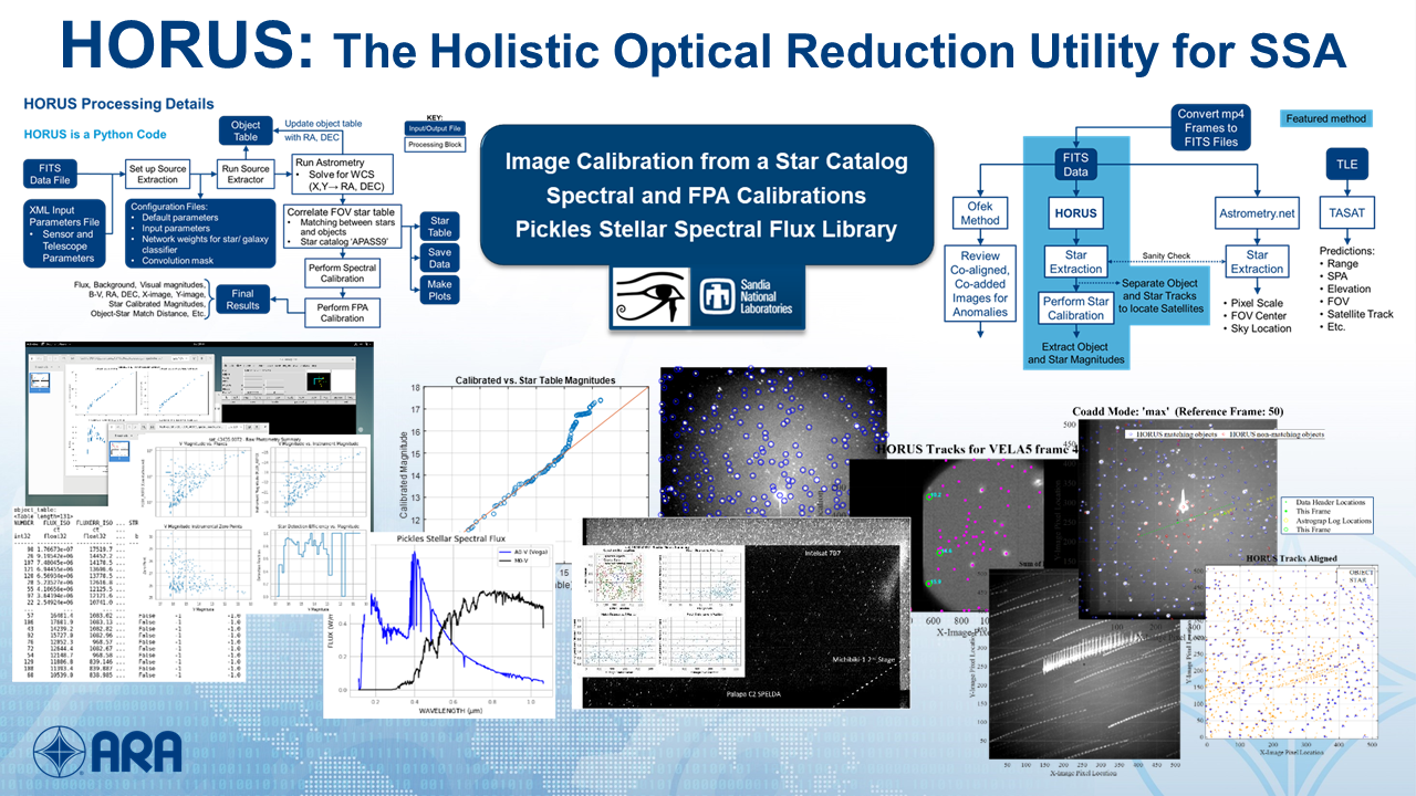
Holistic Optical Reduction Utility for SSA (HORUS)
The HORUS tool provides image calibration from a star catalog. SSA image processing and data extraction was delivered on NASA’s Transiting Exoplanet Survey Satellite (TESS).
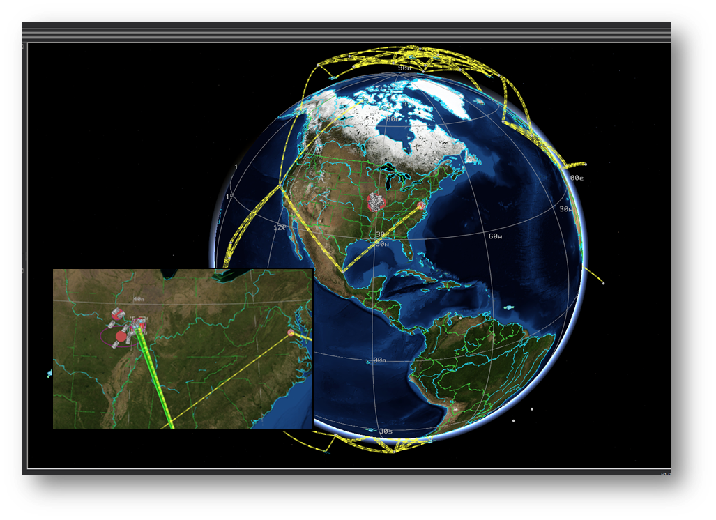
Space ISR (SISR) Simulation
SISR Simulation is a dynamic mission level model of Intelligence, Surveillance, and Reconnaissance (ISR) and communications in an easy-to-use-framework with multiple sensor fidelity. It provides ISR tasking over an area against time sensitive targets via SATCOM. SISR Simulation offers flexible scenario generation and a virtual model mode for integration.
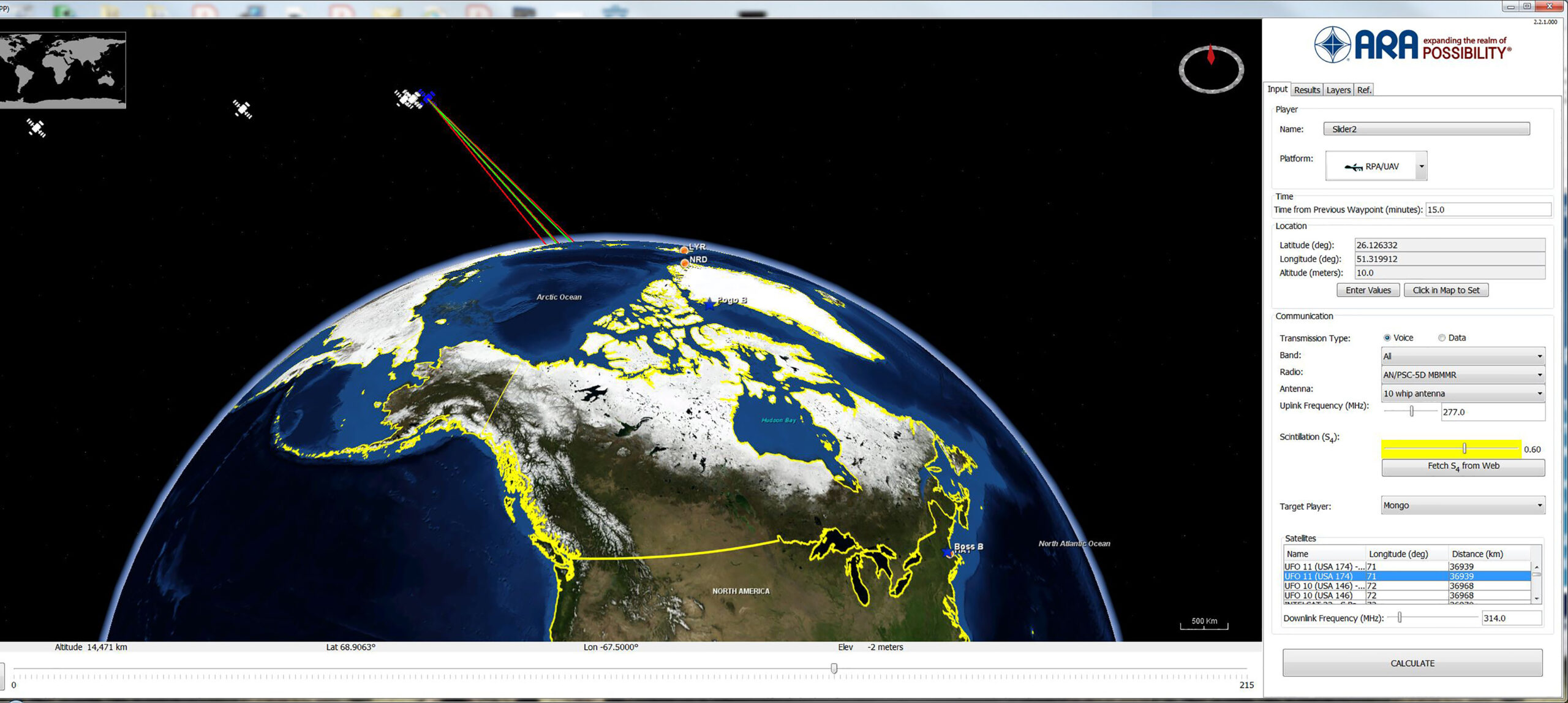
Communication User’s Predictive Product (CUPP)
Developed by ARA for communication situational awareness, CUPP supports mission planning and execution through an easy-to-use model that verifies the reliability of voice and data which includes over 100 communications satellites, radios, transceiver and antenna database, easily edited, as needed. CUPP models terrain masking, power/receive gain variances, and EW interference effects including ionospheric scintillation.
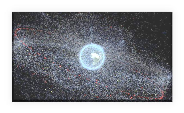
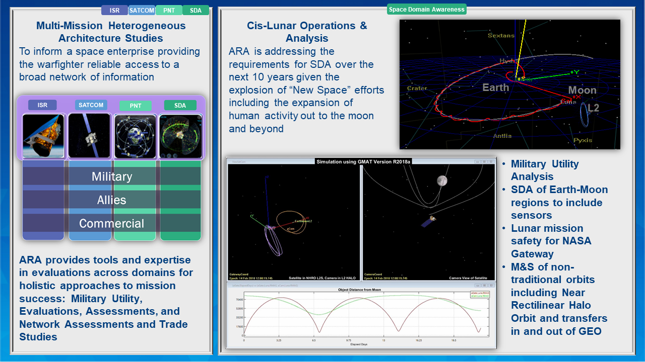
Space Situational Awareness (SSA) 2030+
ARA is addressing SSA 2030+ exploring the requirements for SSA over the next 10 years given the explosion of “New Space” efforts including the expansion of human activity out to the moon and beyond.
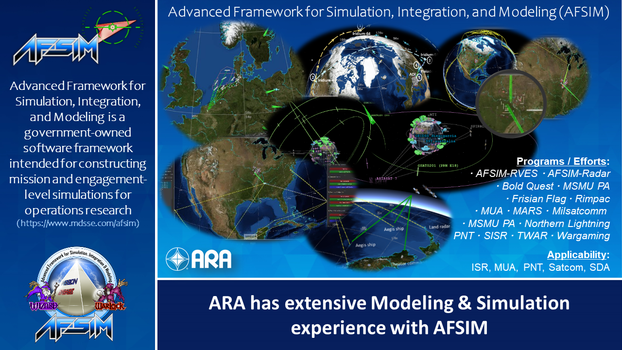
Advanced Framework Simulation, Integration, and Modeling (AFSIM)
AFSIM is one of the government tools for constructing simulations for operations research analyses. ARA implemented a number of scenarios in the AFSIM framework that allow our analysts to model entities and capabilities, and to observe how these entities interact through time. ARA customizes and extends M&S capabilities including plug-in development, scenario scripting, and linking libraries. ARA implemented models in AFSIM for ISR, SATCOM, PNT and SDA dynamic mission modeling, trade studies, and space domain analyses.
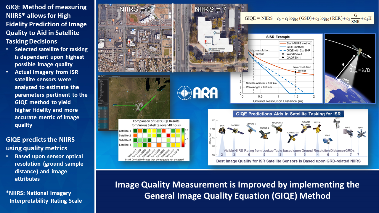
General Image Quality Equation (GIQE)
The space-mission users of the AFSIM space model required improved prediction of image quality for creating realistic Space ISR simulations with realistic constraints. ARA improved measurement of key image quality components by implementing the GIQE method, increasing the number of key image quality assessments accomplished. Combining that information to leverage strengths in areas such as image sharpness and scale, challenge areas such as image noise become less important to determining the overall quality. Actual imagery from ISR satellite sensors were analyzed to estimate the parameters pertinent to the GIQE method to yield higher fidelity and more accurate metric of image quality.
Imaging GEO from Earth
ARA provided systems engineering and technical research for advancing the state-of-the-art and scientific knowledge through innovative concepts and prototyping of electro-optic (EO) SSA concepts, capabilities, and integration both as a complete system and with other SSA systems such as radar, and other EO capabilities to evaluate opportunities to enhance, augment, or provide new capabilities, including the procurement of hardware, for SSA mission areas. ARA supported Inverse synthetic aperture ladar (ISAL) techniques for imaging GEO space objects.
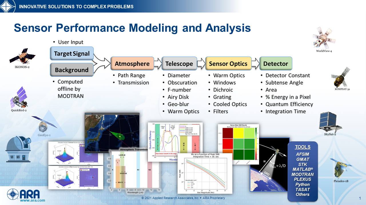
Sensor Performance Modeling and Analysis
Modeling, simulation, and analysis tools have been developed to compute, analyze, and assess EO sensor performance for ground-to-space, space-to-space, and space-to-ground scenarios. Sensor performance metrics include signal-to-noise, visual magnitude, signal returns, and others. Based on Radiometrically traceable data.
Space Domain Analysis Tools
ARA provides tools and expertise in evaluations across all space domains and understands how to integrate and fuse data for warfighter knowledge, for holistic approaches to mission success: military utility, evaluations, assessments, predictions, networks and communications, analyses, and trade studies.
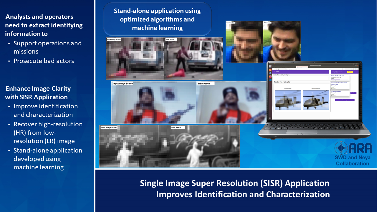
Single Image Super Resolution (SISR)
Image super-resolution technology has broad applications within government, military, law enforcement and commercial sectors. DoD analysts and operators need to extract identifying information from imagery to gain intelligence in support of counterterrorism operations and missions. SISR is a stand-alone computer-based (CPU or GPU) prototype application to improve image clarity by increasing the resolution, capable of enhancing image clarity using the current state-of-the-art machine learning (ML) algorithms.
ARA is providing tools and expertise in the emerging priorities of Space ISR, Communication, and Space Situational Awareness to evaluate technologies and perform space system assessments. ARA’s suite of tools supports Warfighters, mission planners, and communication analysis needs.
This website uses cookies. By clicking "Agree", you agree to the storing of cookies on your device to enhance site navigation, analyze site usage and assist in our marketing efforts.